Searching for Tyres and Other Junk

On the foreshore we locate tyres by fieldwalking, visiting each beach and mudflat all along the coast and rivers at low tide and recording where we find tyres and other dumped rubbish. Finding tyres underwater is more difficult as you can’t see them without diving underwater and even when you are there you can often only see a few metres around you. So instead, we use sonar instruments to make images of the seabed which we interpret to identify all the tyres, cables and other man-made objects.
Sonar instruments work by transmitting a short sound signal into the water, the signal travels through the water to the seabed, bounces off the seabed and anything on it, then the reflected signal travels back to the sonar instrument where it is recorded. We use a side scan sonar instrument mounted on a boat or towed behind it, this transmits signals sideways to the direction of travel, so it builds a picture of what is on the seabed line by line as the boat moves forwards, forming a picture in a long strip. The sonar is effectively two instruments attached together, one creating images on the port side of the boat and the other making an image of the starboard side, with often a small gap between the images under the boat where the sonar cannot see. The side scan sonar can see objects on the seabed but not anything buried in the seabed.
The detail that the image shows will depend on the type of instrument used, so lower cost side scan sonar instruments produce lower quality images. In Plymouth Sound where there is a lot of rubbish on the seabed we find that we need to use the highest quality instrument available. Lower cost instruments may show that there is something on the seabed but a high-quality sonar will be able to show it in better detail so we can see what the object is. Identifying the objects on the seafloor saves a huge amount of expensive diving time underwater, so although the sonar instrument is expensive it is more cost-effective overall.
Most of the tyres and other junk on the seabed in Plymouth Sound has been found using a Solstice sonar from Wavefront Systems Ltd. This is a special kind of side scan sonar that can create an image of the seabed 100m either side of the boat in great detail. Solstice is designed for search, classify and map operations like this, it is small and has a low power consumption so can be mounted on towfish, autonomous boats and underwater vehicles. Solstice also produces bathymetry data so it can map the shape of the seabed as well as objects found on it. You can read more about the Wavefront Solstice sonar here ![]() .
.
The output from the sonar is georeferenced so the images can be imported into processing software so we can record the position and size of any junk on the seabed. This information is added to our digital map of Plymouth Sound and its estuaries.
Click on any picture below to show a larger image.
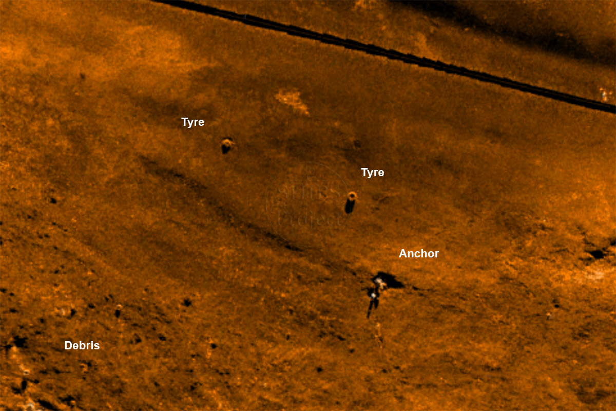
Tyres and an anchor
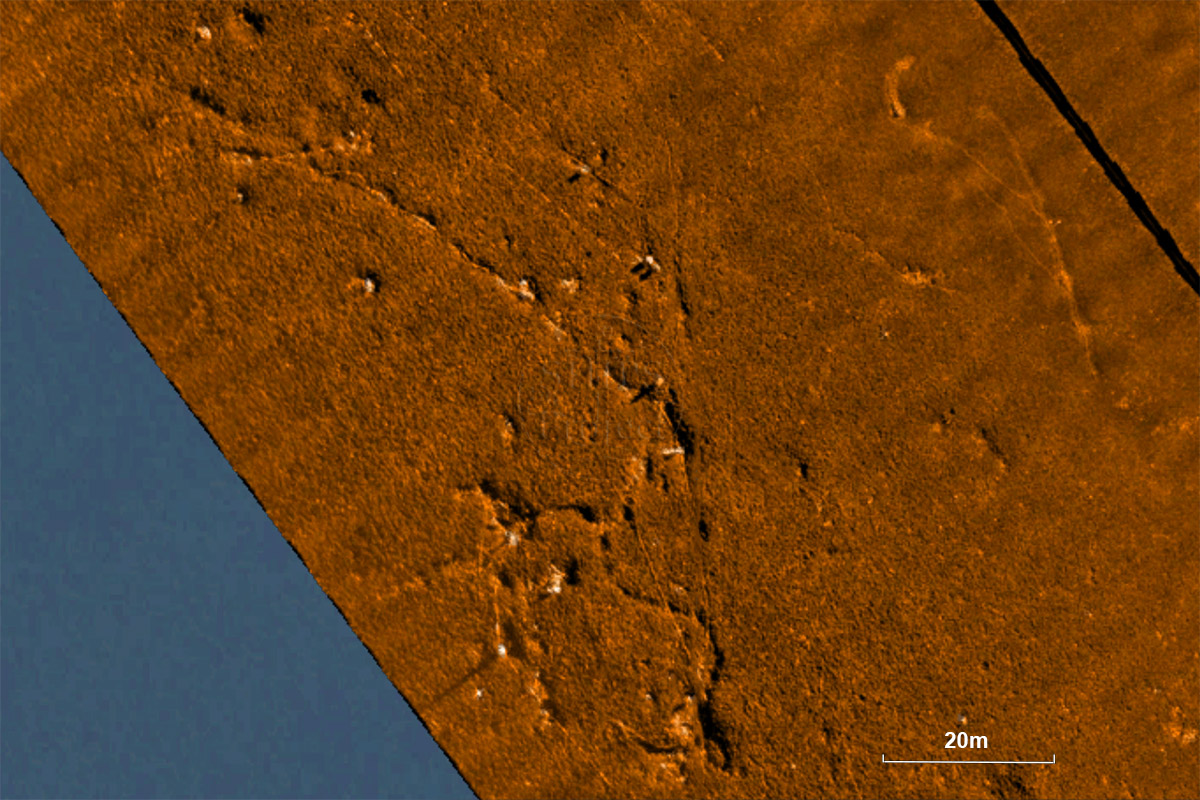
This sonar image shows the seabed in the Cattewater which is mainly flat mud in approximately 10m depth of water. The sonar shows objects clearly on flat, smooth seabeds, here showing two tyres and what we believe to be a lost anchor. In the bottom left corner the texture of the seabed changes where there is a scattering of junk, and at least one object standing proud of the seabed highlighted by the dark shadow next to it.
The black line runing diagonally across the picture is the track of the boat, the line is the missing part of the sonar data under the boat where the sonar cannot 'see', called the 'nadir gap'.
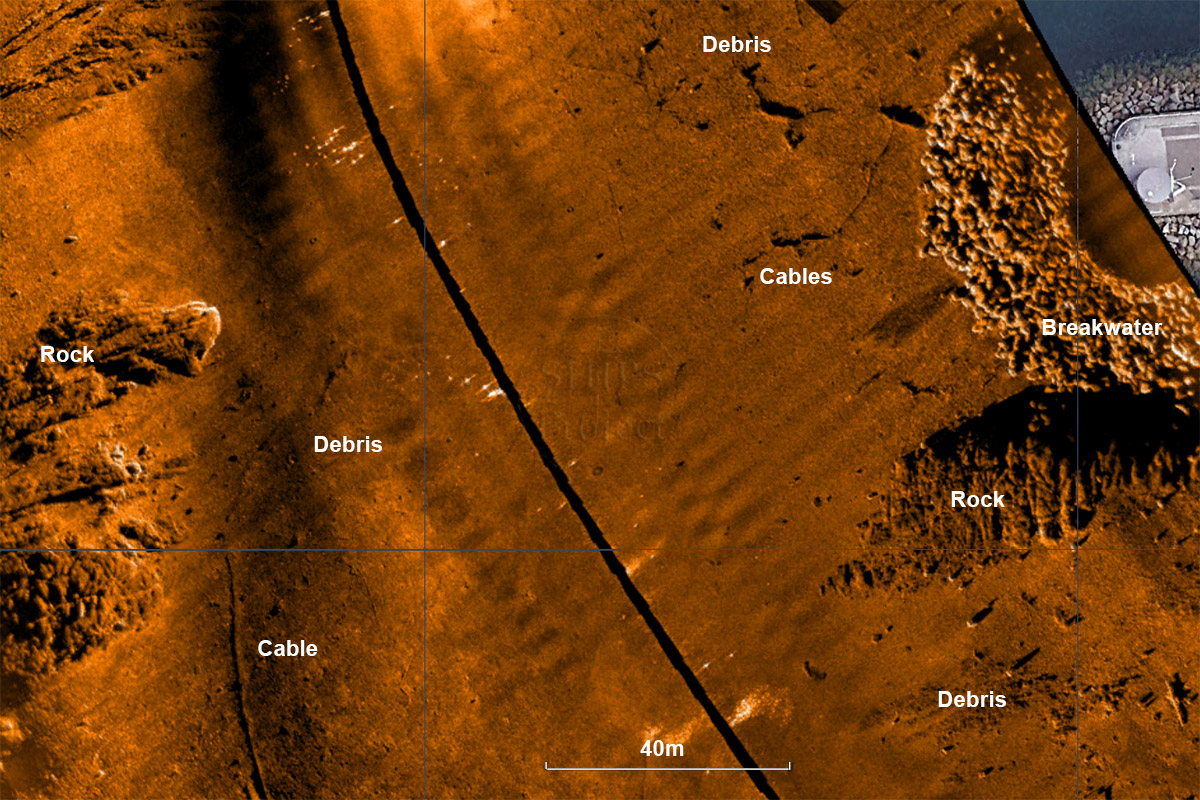
Debris and cables off Mount Batten Pier
This image shows the seabed off the end of the Mount Batten breakwater. The end of the beakwater or pier can be seen on the right with an apron of rock armour around it on the seabed and a small rock outcrop to the south. In the bottom right hand corner is an area of dumped debris, this probably extends over the rock outcrop however the texture of the rock makes it difficult to see the rubbish.
On the left side of the picture is another outcrop of rock which is the eastern side of Mallard Shoal. The flat snady area between Mallard Shoal and the Mount Batten breakwater is covered in dumped cables, tyres and other junk.
Dumped fishing gear
This image shows one side or 'swath' from the sonar image, so the distance from the black line to the edge of the orange sonar trace is 100m.
This image is from Jennycliff Bay, showing the flat sand and mud covered with dumped fishing gear, cables and other unidentifed junk. In the centre is the typical double shadow created by a lost stockless iron anchor sticking up from the seabed.
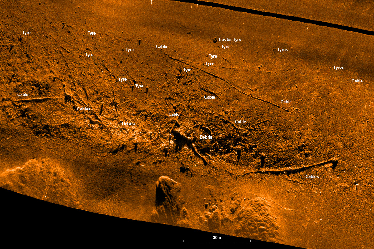
Cables, tyres and other debris on the seabed
Another area of junk Plymouth Sound in about 10m depth, the seabed is mainly flat sand and mud with rock outcrops at the bottom of the picture.
The picture shows cables, junk and tyres strewn over a distance of more than 200m. Note the size of the huge tractor tyre at the top of the picture compared to the many car and truck tyres nearby.
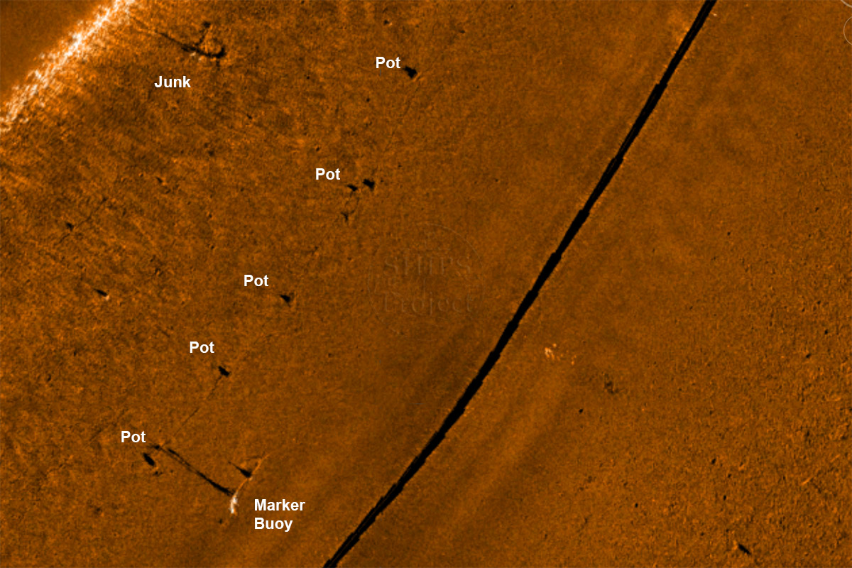
A line of pots on the seabed
The side scan sonar can also be used to locate fishing gear on the seabed. Here a line of crab or lobster pots have been laid on a flat mud seabed in Plymouth Sound, the pots show up as a line of small targets with shadows behind them and in places the rope joining them together can be seen too.
This set of pots was in use and not abandoned as the sonar also shows the pot marker line attached to a buoy on the surface. The sonar allows us to locate lost ghost fishing pots and remove them from the seabed.
The image also shows one or two small unidentified objects on the seabed and a larger item of debris in the top left corner.
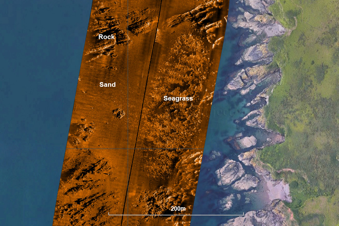
The seagrass bed off Ramscliff Point in Plymouth Sound
The Solstice sonar can also be used to locate and map seagrass beds. This image shows the seagrass bed at Ramscliff on the east side of Plymouth Sound in apprioximately 5m water depth as it was in 2013. You can see the outline of the seagrass bed with rock outcrops to the north and south, and restricted to the west as the water gets too deep for seagrass to grow. The sonar also shows the patchy nature of this partiocular seagrass bed and the associated bathymetry image will show the canopy height.
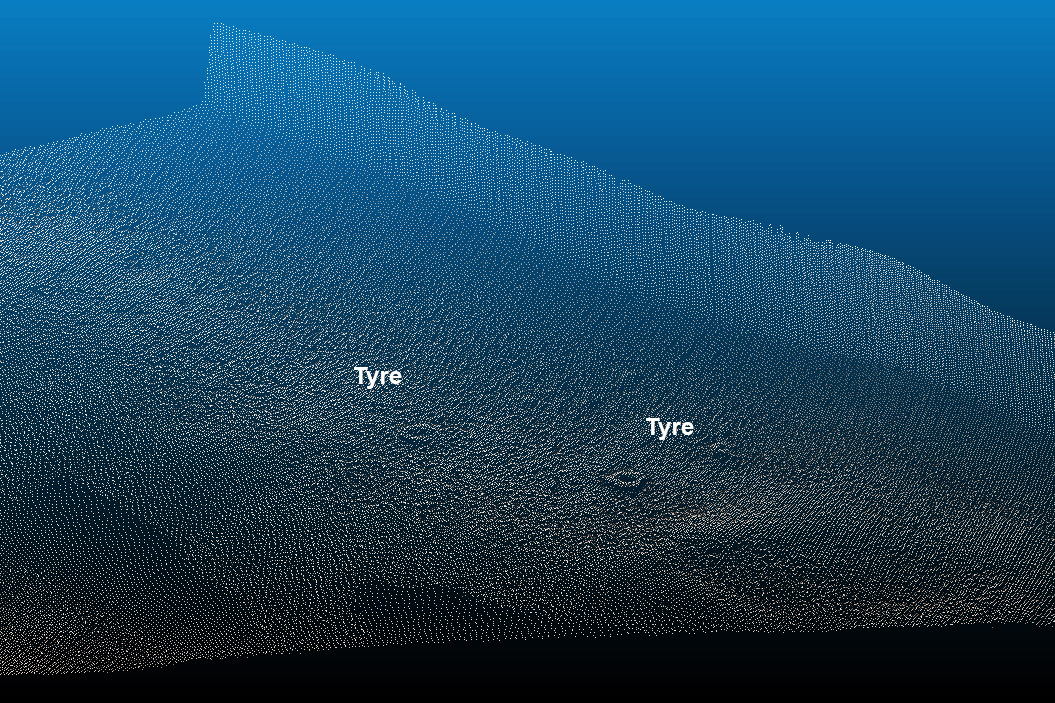
Tyres located by multibeam sonar
Multibeam sonar can also be used to locate tyres and other junk underwater, this point cloud image shows two tyres on the seabed next to a harbour wall.
This image courtesy of Swathe Services Ltd. ![]()
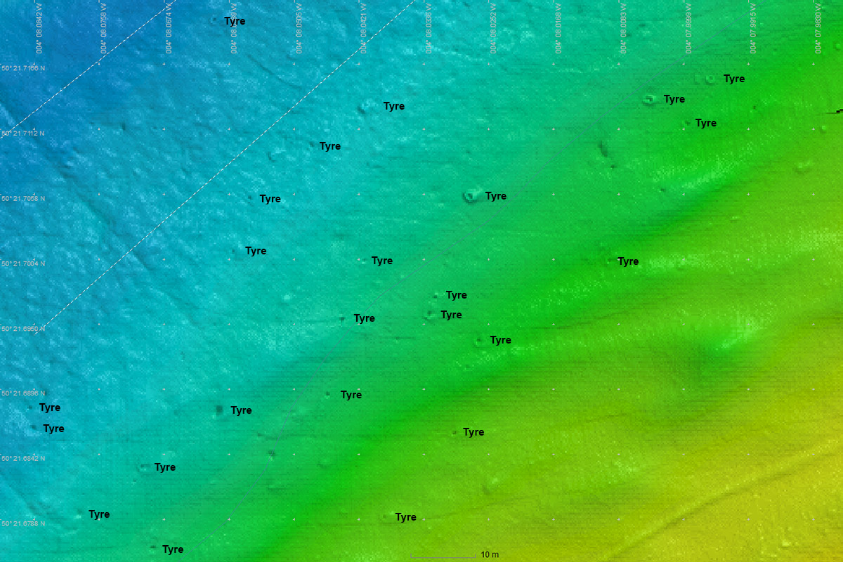
Tyres in the Cattewater located by multibeam sonar
Tyres in the shallow water at the entrance to the Cattewater were visible in multibeam sonar data, but they were not as easy to identify as tyres shown in Solstice side scan sonar images.
This image courtesy of the University of Plymouth.
Data to identify tyres and other junk on the seabed has been kindly provided to The 1000 Tyres Project by Wavefront Systems Ltd. ![]() and Sonardyne International Ltd.
and Sonardyne International Ltd. ![]() .
.
Image use policy
Our images can be used under a CC attribution non-commercial licence (unless stated otherwise).